The Story of the Brandenburg Gate and the Berlin Wall
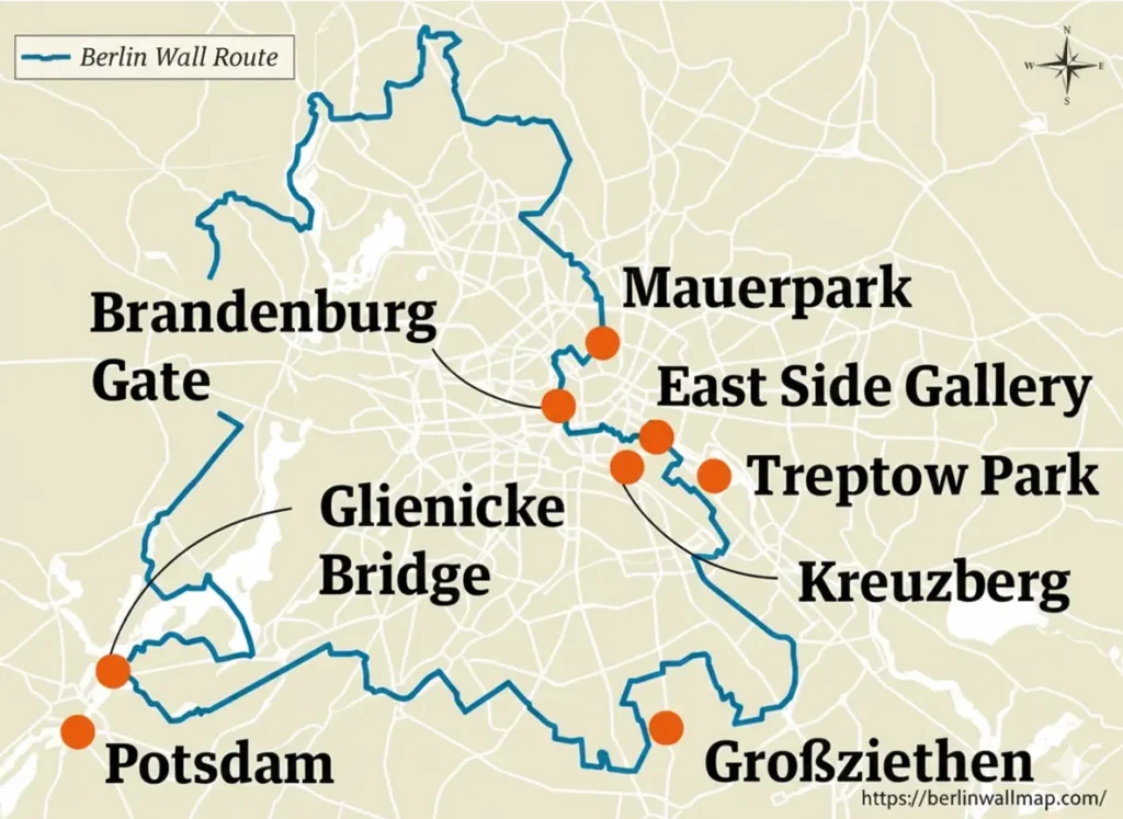
If you look at a map of Berlin from the Cold War era, one landmark stands out as the ultimate symbol of a world split in two: the Brandenburg Gate. For nearly thirty years, this 18th-century monument wasn’t a thoroughfare; it was a dead end.
A Gate to Nowhere
From 1961 to 1989, the Brandenburg Gate sat in a strange sort of limbo. While technically located in East Berlin, it was effectively isolated in a “no-man’s land.” The Berlin Wall didn’t just pass nearby—it curved directly around the gate’s western side along Ebertstraße, cutting it off from West Berlin entirely.
If you were a West Berliner during those years, you could climb a viewing platform and see the gate, but it felt like looking at a relic on another planet.
- The Death Strip: The area surrounding the gate was part of the infamous “death strip,” filled with guard towers, barbed wire, and armed soldiers.
- Pariser Platz: What is now a bustling square was then a desolate, paved-over zone where no public foot traffic was allowed.
- A Silent Sentinel: The gate remained closed for 28 years, serving as a silent witness to the ideological divide between East and West.
The Night the World Changed
Everything shifted on November 9, 1989. As the Wall fell, the Brandenburg Gate became the backdrop for one of the greatest celebrations in modern history. People from both sides climbed the wall in front of the gate, popping champagne and embracing.
On December 22, 1989, the gate was officially reopened. It was no longer a symbol of separation, but a gateway to a new, unified Germany.
Walking the Line Today
If you visit Berlin today, you don’t need a paper map to see where the division was. You can simply look at your feet. A double row of cobblestones is built into the city’s streets, marking the exact path where the Wall once stood.
Modern maps of the area now focus on:
- The Memorial Path: Walking routes that guide you through the former “death strip.”
- Information Panels: Historical markers that explain the struggle for freedom at this exact spot.
- A Unified View: Today, Pariser Platz is filled with tourists, diplomats, and street performers—a stark contrast to the military silence of the 20th century.
Why It Matters
We include the Brandenburg Gate on every Berlin Wall map because it represents the “before and after.” It shows us that even the most formidable walls can eventually come down. It’s a reminder that a place once defined by its barriers can become a world-renowned symbol of peace and unity.