
The Berlin Wall Map – A Divided City
The Berlin Wall Map tells the powerful story of a divided city and a divided world. Built in 1961, the Berlin Wall physically and ideologically separated East and West Berlin for nearly three decades, shaping lives, neighborhoods, and global history.
More than a concrete barrier, the wall reshaped daily life in Berlin. Streets were cut in half, neighborhoods were isolated overnight, and families were separated without warning. It became one of the most powerful symbols of Cold War division.
Today, traces of the Berlin Wall remain visible across the city through memorials, walking paths, preserved wall segments, and historic checkpoints. BerlinWallMap.com provides a clear visual guide showing where the wall once stood and how it evolved between 1961 and 1989.
- Follow the exact route of the Berlin Wall
- Explore preserved wall sections and memorial sites
- Understand the wall’s construction and transformation
- Discover what remains after its fall in 1989
Berlin Wall Today Map to 1961–1989 | Check Complete
The Berlin Wall – A City Divided by the Iron Curtain
For more than 28 years, the Berlin Wall physically separated East Berlin and West Berlin, becoming the most powerful symbol of a Europe divided by the Iron Curtain. Built in 1961, the wall reshaped lives, neighborhoods, and the urban structure of the German capital.
Its primary purpose was to stop the mass migration of citizens from the German Democratic Republic (GDR) to the Federal Republic of Germany (FRG). Over time, it evolved into a highly fortified border system, reflecting the intense political tensions of the Cold War.
Although the wall was largely dismantled after its fall in 1989, its impact remains visible today. The scars it left behind can still be seen in Berlin’s streets, preserved wall segments, memorials, and historical walking routes tracing its former path.
Using detailed maps and visual guides, visitors can explore where the wall once stood, understand how it changed over time, and discover how Berlin continues to remember this powerful chapter of world history.
The Berlin Wall: History Explained on Maps 🌍
More Than Just a Wall
The Berlin Wall was far more than a single concrete barrier. It was a vast and highly fortified military border system designed to prevent escapes from East Berlin to the West.
At its peak, the barrier consisted of multiple layers of defenses, including two parallel concrete walls standing approximately 12 feet (3.6 meters) high, reinforced with watch paths, floodlights, alarm systems, and anti-vehicle trenches.
- Over 300 watchtowers and observation posts monitored the border
- Approximately 14,000 armed guards were stationed along the wall
- More than 600 trained guard dogs patrolled restricted zones
- Extensive barbed wire and signal fencing covered escape routes
Despite these measures, many people attempted to cross the wall in search of freedom. An unknown number lost their lives during escape attempts, becoming victims of gunfire, land obstacles, or other deadly security measures enforced by East German border guards and Soviet forces.
The Berlin Wall remains a powerful symbol of division, control, and human resilience — and a reminder of the high cost paid by those who dared to challenge it.
What Was the Berlin Wall?
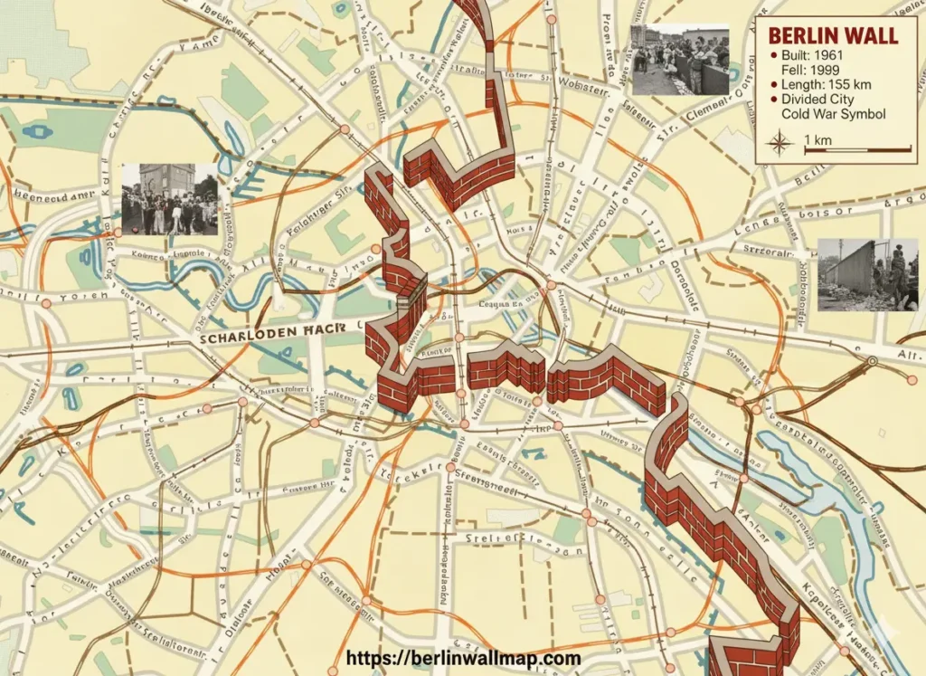
The Berlin Wall was erected on August 13, 1961, by the German Democratic Republic (East Germany) to prevent East Berliners from fleeing to the West. Stretching over 155 kilometers (96 miles), the wall encircled West Berlin, separating it from East Germany and East Berlin.
The wall consisted of concrete barriers, guard towers, anti-vehicle trenches, and a “death strip” that made escape nearly impossible. Over its 28 years of existence, it became a potent symbol of political oppression, division, and the ideological conflict between communism and democracy.
Historical Context of the Berlin Wall
After World War II, Germany was divided into four occupation zones controlled by the United States, the United Kingdom, France, and the Soviet Union. Berlin, although located deep within the Soviet zone, was similarly divided into four sectors.
Tensions between the Soviet Union and Western Allies escalated during the Cold War, leading to a mass exodus of East Germans to West Berlin. In response, the East German government constructed the Berlin Wall to stem the tide of emigration and assert control over its population.
Berlin Wall Map – Why It’s Important
A Berlin Wall Map allows visitors and researchers to locate key historical points, remaining wall segments, memorials, and museums. Since much of the wall was demolished after November 9, 1989, it’s essential to use a map to identify surviving sections and areas of historical significance.
- East Side Gallery – A 1.3 km long section covered in murals by international artists.
- Berlin Wall Memorial (Gedenkstätte Berliner Mauer) – Includes original wall segments, guard towers, and exhibitions.
- Checkpoint Charlie – Famous crossing point between East and West Berlin.
- Potsdamer Platz – Once a no-man’s land; today, a symbol of Berlin’s revival.
- Bernauer Strasse – Site of dramatic escapes and a preserved stretch of the wall.
Sections of the Berlin Wall Today
While most of the Berlin Wall was dismantled after 1989, several sections remain today, serving as powerful reminders of history. Visitors can explore these sites to understand the wall’s impact, witness its remnants, and reflect on Berlin’s journey from division to unity.
1. East Side Gallery
The East Side Gallery is the largest remaining portion of the Berlin Wall, stretching 1.3 kilometers along the Spree River. It features over 100 murals painted by artists from around the world, turning this historic site into a vibrant open-air gallery that celebrates freedom, creativity, and remembrance.
2. Berlin Wall Memorial
Located at Bernauer Strasse, the Berlin Wall Memorial preserves original wall segments, guard towers, and the infamous “death strip”. Visitors can explore the documentation center and exhibitions that detail the wall’s construction, political significance, and the dramatic escape attempts of those who sought freedom.
3. Checkpoint Charlie
Checkpoint Charlie was the most famous border crossing between East and West Berlin during the Cold War. Today, the site features a replica of the guardhouse, historical photographs, and museums recounting daring escapes, political confrontations, and the tense atmosphere of a divided city.
4. Potsdamer Platz
Once split by the Berlin Wall, Potsdamer Platz is now a bustling square featuring modern architecture and commercial hubs. Historical markers and small fragments of the wall provide visitors with insights into its past as a heavily monitored border zone.
5. Other Notable Segments
- Mühlenstrasse – Preserved wall sections with historical plaques and informative displays.
- Friedrichstrasse Station – Former border crossing point, now a museum preserving its Cold War history.
- Glienicke Bridge – Known as the “Bridge of Spies,” famous for Cold War prisoner exchanges between East and West.
Exploring these sections of the Berlin Wall today offers a unique opportunity to witness history, reflect on the struggles of a divided city, and appreciate Berlin’s journey toward freedom and reunification.
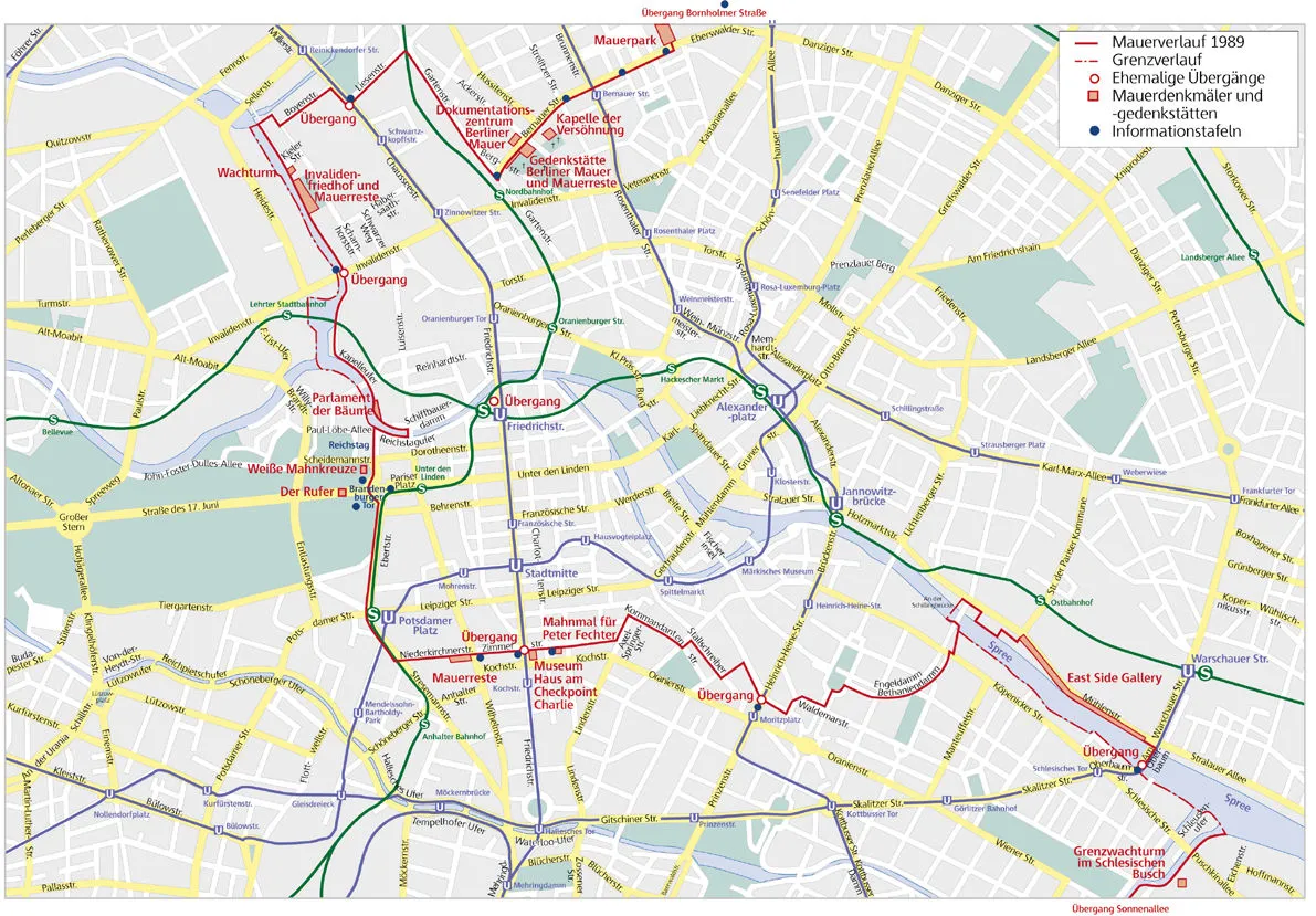
Old Berlin Wall Map (Historic View)
The old Berlin Wall map visually shows how the wall once cut through the heart of the city, dividing neighborhoods, streets, and families. This historic map highlights the exact route of the Berlin Wall, including guarded zones, watchtowers, and famous crossing points like Checkpoint Charlie. When viewed alongside a Berlin divided map, it helps readers understand the real scale of separation and why Berlin became the strongest symbol of the Cold War.
Image caption (for use under the image):
Historic Berlin Wall map showing the division between East and West Berlin during the Cold War era.
Using a Berlin Wall Map for Tours
A Berlin Wall Map is essential for anyone planning a historical tour of Berlin. Follow these steps to make the most of your visit and explore the city’s rich Cold War history.
Step 1: Identify Major Landmarks
Start with major landmarks like the East Side Gallery, Checkpoint Charlie, and the Berlin Wall Memorial. These locations are usually clearly marked on most Berlin Wall maps.
Step 2: Plan Your Route
Berlin’s public transport system is efficient, and most Wall landmarks are accessible by U-Bahn, S-Bahn, or bus. Use your map to cluster nearby attractions and minimize travel time for a smooth tour experience.
Step 3: Guided Tours
Consider joining guided tours for detailed historical insights. Many tours use Berlin Wall Maps to trace escape routes, original wall locations, and significant Cold War events.
Step 4: Self-Guided Exploration
For a more personal experience, use a digital Berlin Wall Map on your smartphone. Many apps provide GPS navigation and historical information about each site.
Educational Significance
The Berlin Wall serves as a powerful educational tool for understanding Cold War history, German reunification, and the human impact of political division. Teachers, students, and history enthusiasts can use the Berlin Wall Map to:
- Locate memorial sites for field trips
- Study the wall’s impact on Berlin’s urban development
- Explore escape stories and personal accounts
- Understand the socio-political climate of East and West Germany
Berlin Wall Map – Digital vs Physical
Digital Maps
- Interactive maps: Provide GPS navigation, images, and historical data.
- Apps: Some offer augmented reality to visualize how the wall looked during its existence.
- Advantages: Up-to-date, easy to carry, real-time directions.
Physical Maps
- Historical maps: Show the wall as it existed in the 1960s–1980s.
- Tourist maps: Highlight remaining wall sections and museums.
- Advantages: Useful for planning tours, collecting as memorabilia, and offline reference.
Famous Escape Stories
The Berlin Wall witnessed numerous daring escape attempts. Modern Berlin Wall Maps often mark these routes, offering a glimpse into the courage and ingenuity of those seeking freedom.
- Tunnel 57: In 1964, 57 East Berliners escaped through a tunnel dug under the wall.
- Flying Escape: In 1979, a man and his wife escaped using a homemade air balloon.
- Car Escapes: Several people modified vehicles to break through checkpoints.
Frequently Asked Questions
Q1: Where was the Berlin Wall located?
The Berlin Wall ran through the center of Berlin, separating East Berlin from West Berlin, surrounding West Berlin entirely.
Q2: Can you still see the Berlin Wall today?
Yes, several sections remain, including the Berlin Wall Memorial, East Side Gallery, and other marked locations along the original route.
Q3: How long was the Berlin Wall?
The Berlin Wall stretched approximately 155 kilometers (96 miles) around West Berlin.
Q4: When did the Berlin Wall fall?
The Berlin Wall fell on November 9, 1989, leading to German reunification.
Q5: Is there a walking route along the Berlin Wall today?
Yes, the Berlin Wall Trail allows visitors to walk or cycle along the former route of the wall.